


ホーム » Volcanic disaster prevention information
Volcanic disaster prevention information
Volcanic disaster prevention information
This page introduces basic information about volcanoes, such as the properties of volcanic ash and disaster prevention information regarding volcanoes.
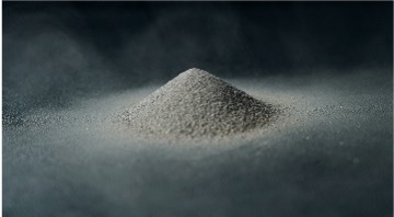
Main characteristics of volcanic ash

Very fine particles
The particles are extremely fine, less than 2 millimeters in diameter, so they are easily carried downwind by the wind, causing widespread damage.
In addition, volcanic ash that has accumulated on the ground can be stirred up again, causing problems such as reduced visibility.

Hard and pointed
It is made up of tiny pieces of glass and mineral crystals, and is hard and angular in shape.
Therefore, if you try to wipe volcanic ash off of a car or other surface, it can leave small scratches, and inhaling a large amount can pose health risks.

Conducts electricity
When dry, volcanic ash is an insulator, but when it becomes wet, it can become conductive due to the volcanic gas components and bases that adhere to the ash, which can cause flashovers and power outages.

There is little risk of contact
Since the danger of coming into contact with volcanic ash is low, it is not life-threatening.
However, volcanic ash can irritate the eyes, nose, throat, trachea, lungs, etc., and may cause health problems.

It won't go away
unless you remove it
Unlike snow, it does not melt or disappear over time, so removal work is required.
Key terms for disaster prevention information regarding volcanoes
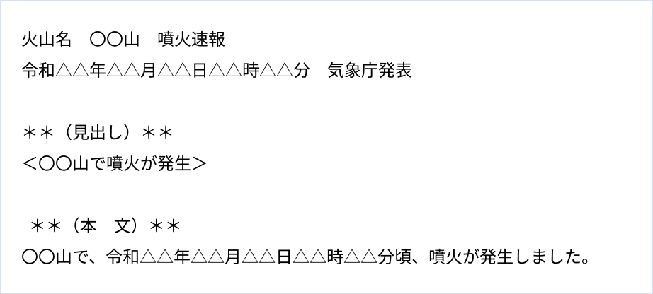
- Eruption Alert
This is information to inform climbers and nearby residents of an eruption. The Japan Meteorological Agency issues this announcement in order to inform them quickly and concisely that a volcano has erupted, so that they can take action to protect themselves.
In order to notify people as quickly as possible of the fact that an eruption has occurred, the only information provided is the name of the volcano and the time of the eruption.
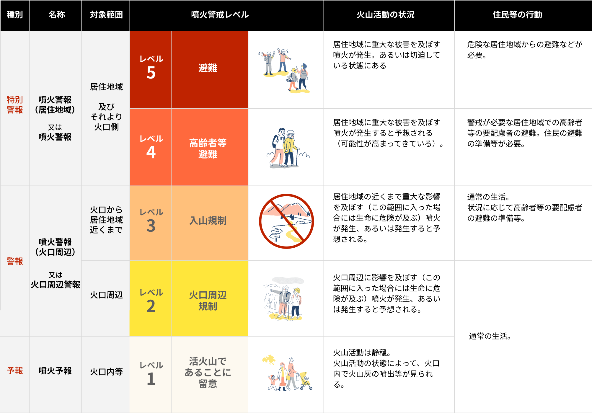
- Volcanic alert level
This is an index that divides the “areas requiring caution (areas that pose a danger to life)” according to the state of volcanic activity into five levels, as well as the “disaster prevention measures that should be taken” by disaster prevention agencies and residents. It is announced in conjunction with eruption warnings and eruption forecasts.
After discussions at the Volcano Disaster Prevention Council established by the local prefectures of each volcano, the “areas requiring caution” and “disaster prevention measures that should be taken” according to the eruption alert level are used for volcanoes specified in the local disaster prevention plans of municipalities and prefectures.
- Volcanic eruption warnings and forecasts
- An eruption warning is a forecast that warns of the possibility of serious disasters related to an eruption. The Japan Meteorological Agency issues an eruption warning, clearly indicating the name of the volcano and the area requiring caution (area that poses a danger to life), when a life-threatening volcanic phenomenon is expected to occur (such as large volcanic blocks, pyroclastic flows, and snow-melt volcanic mudflows that reach the crater area or residential areas a short time after occurring, leaving little time for evacuation) or when the area of danger is expected to expand. For volcanoes that operate eruption alert levels, the eruption alert level is also included in the announcement.
- An eruption forecast is an announcement of a prediction of volcanic phenomena related to an eruption based on the results of observations. The Japan Meteorological Agency issues an eruption forecast when volcanic activity is calm or when volcanic activity is not expected to warrant an eruption warning. For volcanoes that operate eruption alert levels, an eruption alert level of 1 (please note that it is an active volcano) is issued.
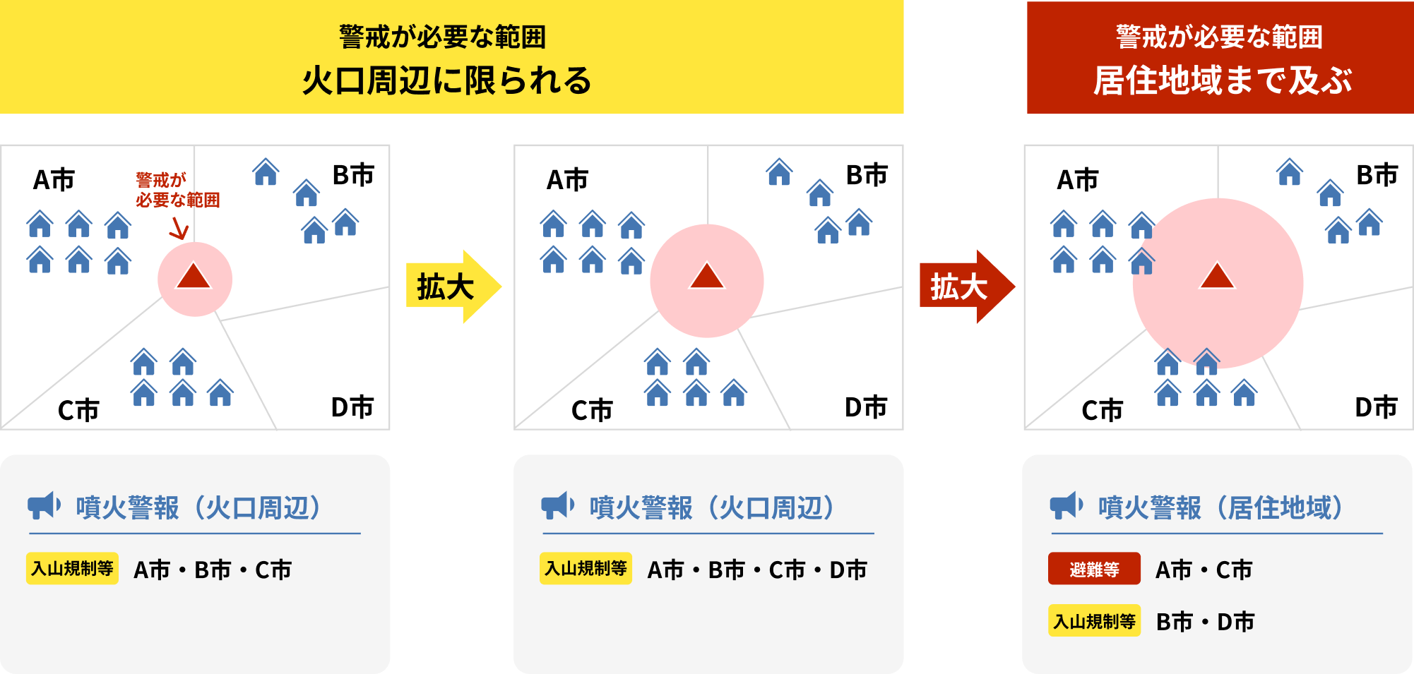
○ The “area requiring caution” is not necessarily a concentric circle, but is set based on volcanic hazard maps for each stage of volcanic activity. For more information, please feel free to contact your local city, town, or meteorological station.
◯Please also check the leaflets for each volcano.
https://www.data.jma.go.jp/vois/data/tokyo/keikailevel.html(Japan Meteorological Agency website)
- Interpretive information on the status of the volcano
At present, it is unlikely that the eruption alert level will be raised or the area requiring alert will be expanded, but the Japan Meteorological Agency will issue information in a timely manner if it determines that it is necessary to communicate the status of volcanic activity, such as when changes in volcanic activity have been observed.
In contrast, when the current situation has not yet reached the criteria for raising the eruption alert level, or when the area requiring alert is not expanding, but it is judged that there is a possibility of this happening depending on future progress in activity, or when it is unclear whether to make a decision, information to convey the status of volcanic activity and matters requiring alert and caution in terms of disaster prevention is called “explanatory information on the status of volcanoes (temporary).”
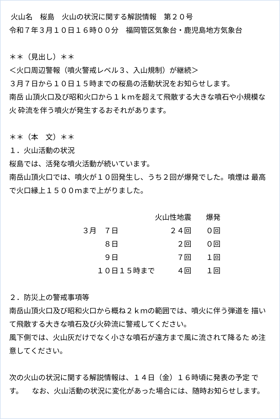
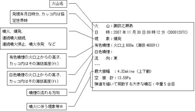
- Volcano observation report on eruptions
This is information that informs you that an eruption has occurred and information related to the eruption (such as the time of the eruption, the height of the plume, the direction of the plume, volcanic phenomena observed in conjunction with the eruption, etc.).
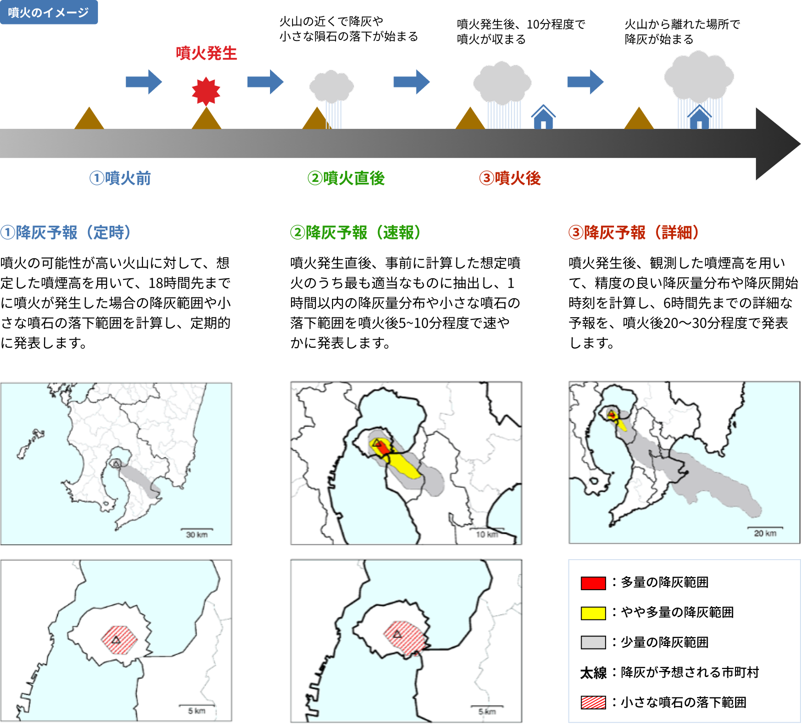
- Ash fall forecast
This information provides predictions of where and how much volcanic ash will fall due to an eruption (ash fall distribution), as well as the range over which small volcanic rocks will fall, carried by the wind.
- Ashfall Classification Table
The amount of ashfall is expressed in classes to make it easier to understand and to take disaster prevention measures.
Ashfall is categorized into three classes depending on the thickness: “large amount,” “slight amount,” and “light amount.” The ashfall class table shows the “ashfall situation,” “impact of ashfall,” and “response actions to be taken” for each class.
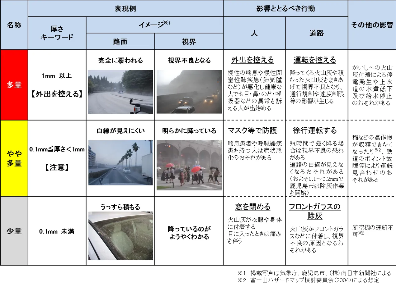
Source: Japan Meteorological Agency website
(https://www.jma.go.jp/jma/kishou/know/kazan/qvaf/qvaf_guide.html)
“Ashfall Classification Table”
For more information on volcano disaster prevention information and terminology, please click here.