


ホーム » Learn about the eruption of Mount Fuji

Learn about the eruption of Mount Fuji

Learn about the eruption of Mount Fuji
This page introduces the history and characteristics of eruptions of Mount Fuji, which has erupted many times in the past.
Overview of Mt. Fuji
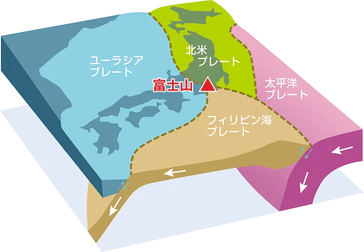
- Mount Fuji is one of the 111 active volcanoes in Japan, located across Shizuoka and Yamanashi prefectures in the area where the Philippine Sea Plate, North American Plate, and Eurasian Plate meet.It is a basaltic stratovolcano that belongs to the Fuji volcanic belt.
- With an elevation of 3,776m, it is the highest mountain in Japan, and with a volume of approximately 500km2, it is the largest volcano on land in Japan.
- The gradient of the mountainside slope is gentle (less than 10 degrees) below 1,000 m above sea level, but becomes steeper as the altitude increases (nearly 40 degrees near the summit).
- From within Tokyo, the mountain peak can be seen with the Tanzawa Mountains in the background, and place names such as Fujimizaka remain in various parts of Tokyo.
- The distance from the summit crater of Mount Fuji to Tokyo is approximately 47 km to the nearest Yamanashi Prefecture border in Hinode Village and approximately 115 km to the farthest Chiba Prefecture border in Katsushika Ward.
Characteristics of the Mount Fuji eruption
Mount Fuji is divided into the “Old Fuji Volcano”, which was active from about 100,000 to 10,000 years ago, and the “New Fuji Volcano”, which has been active since then up to the present. The main characteristics of the eruptions of the “New Fuji Volcano” that have been revealed through research so far are as follows:
- The types of eruptions are pyroclastic eruptions, lava flow eruptions, and mixed types of these, and a few pyroclastic flows have also been observed.
- The summit crater has erupted repeatedly from the same crater, but there are no known cases of a side crater erupting from the same crater.
- The vast majority of eruptions are small-scale.
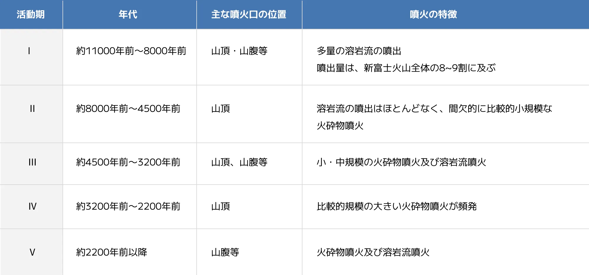
In addition, Mount Fuji eruptions are characterized by the emission of lava flows and pyroclastic materials (volcanic ash, lapilli, and other fragmented material) from the summit crater and side craters (craters on the mountainside other than the summit), and can be classified into five active periods based on the location of the crater and the type of material ejected, as shown in the table below.
History of Mount Fuji eruptions
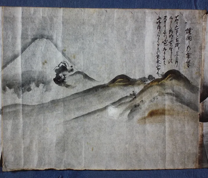
Records of Mount Fuji’s eruptions are written in historical documents such as ancient texts, and at least 10 highly reliable records indicate that it has erupted since 781.
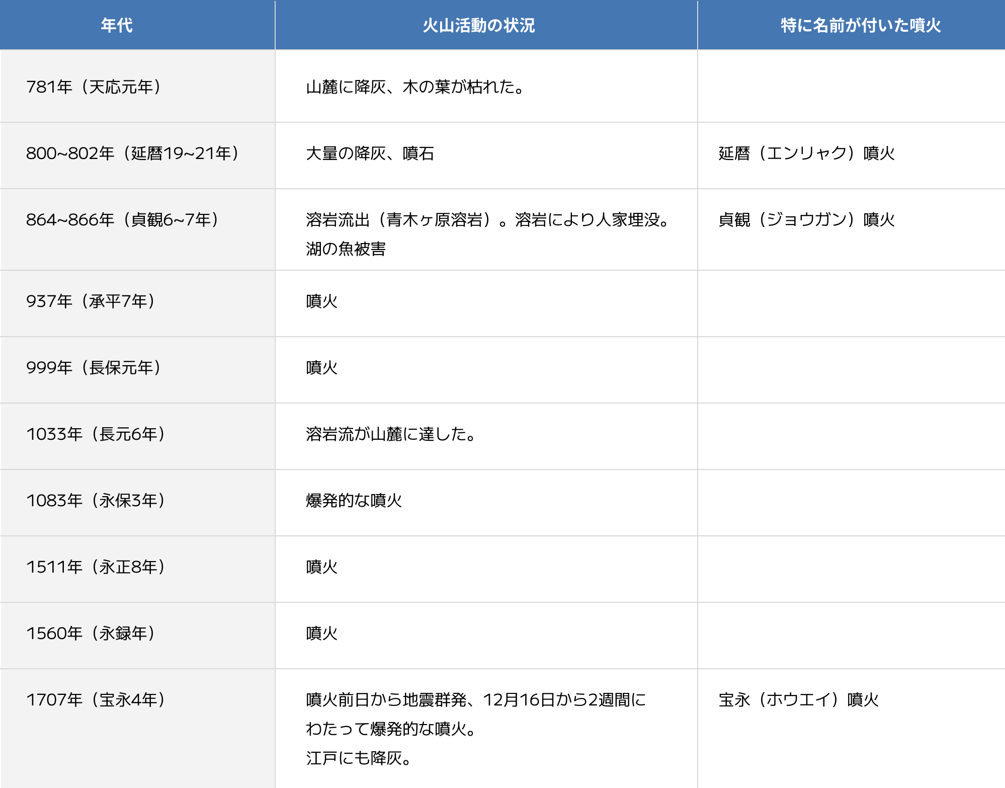
As mentioned above, the vast majority of Mount Fuji eruptions have been small-scale, and most only leave brief descriptions of them.
Of these, the Hoei eruption, which had a major impact as far away as Edo (present-day Tokyo), is well described in historical documents and gives us an idea of what it was like at the time.
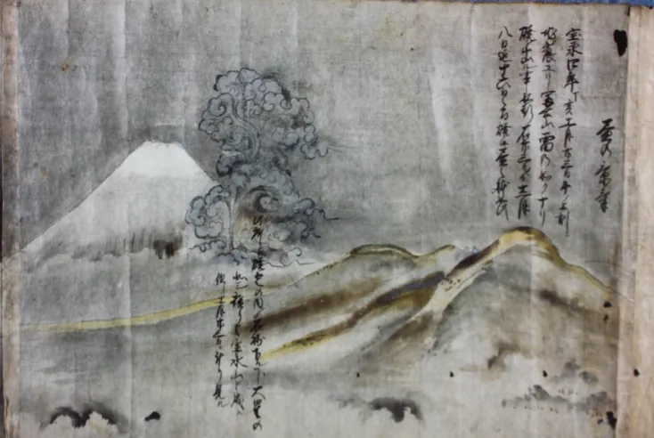
Hoei Eruption in the Edo Period
The Hoei eruption is said to be the largest eruption of Mount Fuji in the last 8,000 years.
This eruption occurred on the southeastern slope of Mount Fuji on November 23rd (December 16th), 1707 (the 4th year of the Hoei era), approximately 300 years ago.
The eruption continued intermittently for 16 days, until the early hours of December 9th, and ejecta such as volcanic gravel and ash that spewed from the newly opened Hoei crater was carried by the westerly winds and fell on everything from northeastern Shizuoka Prefecture to northwestern Kanagawa Prefecture, Tokyo, and even as far as the Boso Peninsula, more than 100 km away.
The estimated 1.7km³ of ejecta (equivalent to 0.7km³ of magma) had a widespread and enormous impact on production and economic activities, particularly agriculture and forestry, including the collapse of buildings, rendering farmland uncultivable, devastation of forests and grasslands, and the flooding of irrigation channels and rivers caused by the volcanic ash that flowed out. If we were to apply this to modern society, the estimated economic damage is estimated to be on the scale of 1.2 to 2.5 trillion yen (Mt. Fuji Hazard Map Review Committee Report).
Mount Fuji Hazard Map
A volcanic hazard map is a map that identifies areas that may be affected by volcanic disaster factors and depicts them visually in an easy-to-understand manner. The volcanic hazard map for Mt. Fuji was created in 2004 by the Mt. Fuji Volcano Disaster Prevention Council and the Mt. Fuji Hazard Map Review Committee.It was subsequently revised in 2021 based on new scientific findings, and is now being used to create volcanic disaster prevention maps, etc. The Mt. Fuji Hazard Map anticipates damage caused by widespread ashfall in the Tokyo metropolitan area, including Tokyo, and the “Possible Ashfall Map” allows users to check the extent of ashfall, etc.
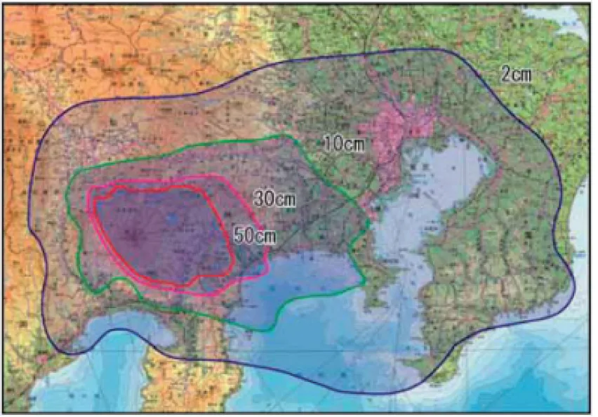
Ash fall distribution map
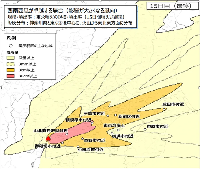
- In 2018, the "Working Group to Consider Wide-Area Ash Fall Measures in the Event of a Large-Scale Eruption" (hereinafter referred to as the "Working Group") was established under the Disaster Prevention Measures Executive Committee of the Central Disaster Prevention Council to consider ash fall countermeasures for a wide area including Tokyo and the greater Tokyo region, using an eruption on the scale of the Hoei eruption of Mount Fuji as a model case. As part of this effort, the Working Group created a "Ash Fall Distribution Map" as basic information for predicting the impact of ash fall and considering appropriate countermeasures.
- The ash fall distribution map shows how much volcanic ash will fall in which area, based on conditions such as the scale of the eruption and wind direction. Specifically, a time-series distribution of ash fall has been created for each of the following three cases:
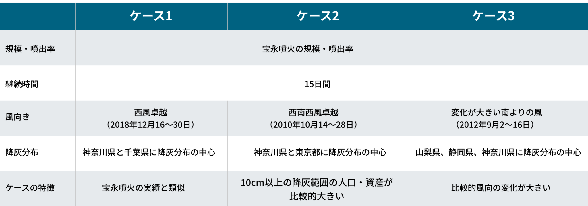
*This assumption is merely an example for consideration, and does not predict the conditions of a future Mt. Fuji eruption.
It is important to understand that in the event of an actual eruption, ash fall conditions will change depending on wind direction, the scale and duration of the eruption, etc.
In the report “Regarding wide-area ashfall countermeasures in the event of a large-scale eruption – Impacts of ashfall and countermeasures in the Tokyo metropolitan area – Using the eruption of Mt. Fuji as a model case” published by the working group in April 2020,
Source: Regarding wide-area ashfall countermeasures in the event of a large-scale eruption – Impacts of ashfall and countermeasures in the Tokyo metropolitan area – Using the eruption of Mt. Fuji as a model case (report) [Attached materials]

Case 2: The impact on Tokyo is the greatest
- Ashfall of 2 to 10 cm or more occurred in most wards, including the Tama area.
- The amount of volcanic ash that needs to be removed within Tokyo is approximately 120 million m3.
- The total amount of volcanic ash that needs to be removed is estimated at about 4.9 billion m3, more than 10 times the amount of disaster waste generated by the Great East Japan Earthquake.
*This assumption is merely an example for consideration, and does not predict the conditions of a future Mt. Fuji eruption.
It is important to understand that in the event of an actual eruption, ash fall conditions will change depending on wind direction, the scale and duration of the eruption, etc.